Scan to BIM: digitaliza la realidad física con precisión milimétrica
Convierte nubes de puntos en modelos BIM inteligentes y editables. La base sólida obligatoria para cualquier proyecto de remodelación, ampliación o gestión de activos existentes.
Solicita una Cotización¿Qué es el servicio Scan to BIM?
Es el proceso técnico de transformar los datos masivos de un escáner láser 3D (Nube de
Puntos) en un modelo BIM paramétrico y organizado (Revit, Archicad).
En lugar de "calcar" planos antiguos que suelen ser incorrectos, modelamos sobre la realidad
capturada. Esto es vital para ingenieros y arquitectos que necesitan certeza
geométrica absoluta antes de diseñar nuevas instalaciones sobre estructuras
existentes.
- ✓ Cero Errores de Levantamiento: Eliminamos la incertidumbre de las mediciones manuales y los "vicios ocultos" geométricos.
- ✓ Modelos Editables: Entregamos archivos nativos listos para que tu equipo empiece a diseñar inmediatamente.
- ✓ Detección de Interferencias: Identifica choques entre estructuras actuales y nuevos diseños MEP antes de construir.
- ✓ Patrimonio Digital: Documentación histórica precisa para restauración o preservación de activos complejos.
¿Para quién es?
Remodelaciones
Arquitectos trabajando en edificios existentes.
Retrofit MEP
Ingenierías actualizando instalaciones.
Plantas Industriales
Ampliaciones complejas y revamping.
Patrimonio
Restauración de edificios históricos.
BIM Managers
Que requieren un punto de partida fiable.
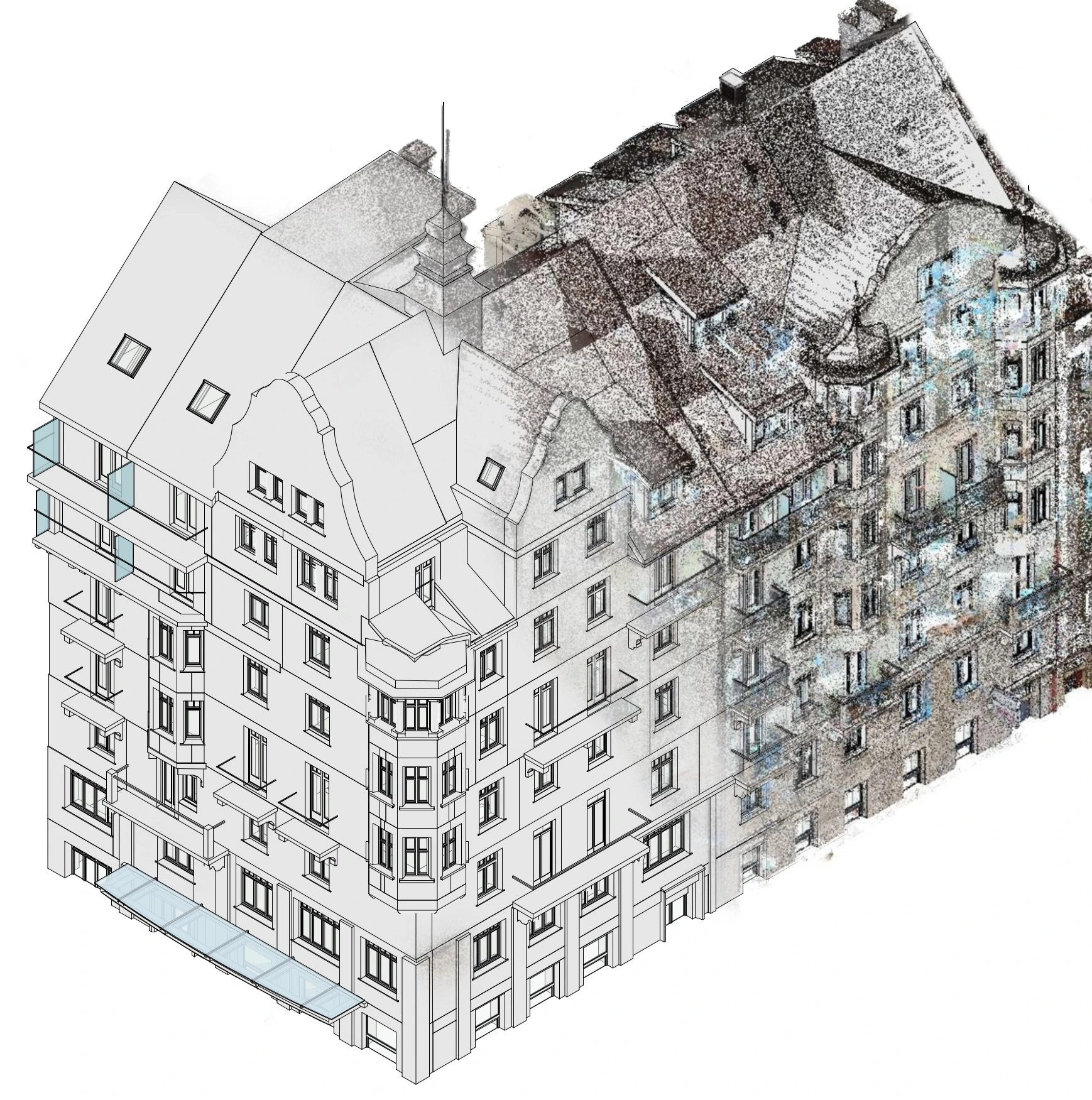
Proceso Foundtech
De la nube de puntos al modelo entregable.
Captura & Registro
Escaneo láser en sitio y procesamiento para unificar la Nube de Puntos completa.
Modelado
Nuestros modeladores levantan la geometría BIM basándose estrictamente en la nube.
Validación
Superposición del modelo vs. nube de puntos para garantizar desviaciones mínimas.
Entrega
Archivos editables (RVT, PLA) y planos generados listos para tu equipo.
Beneficios Clave
- ✓ Eficiencia: Reduce tiempos de modelado hasta en un 40% vs métodos tradicionales.
- ✓ Confiabilidad: Trabaja con datos reales, no con suposiciones obsoletas.
- ✓ Mitigación de Riesgos: Evita órdenes de cambio costosas por errores de información base.
- ✓ Compatibilidad: Entregables listos para integrarse en tu flujo BIM estándar.
- ✓ Seguridad: Reducimos la necesidad de múltiples visitas a sitio y exposiciones a riesgos.
- ✓ Facilita el Diseño Remoto: Tu equipo tiene el sitio "virtualizado" en su oficina desde el primer día.
- ✓ Documentación Legal: Un registro "congelado en el tiempo" del estado exacto del activo.
- ✓ Visualización Premium: Material impactante para presentar a inversionistas o dueños.
Preguntas Frecuentes
Nos adaptamos a tu requerimiento, desde LOD 200 (volumétrico) hasta LOD 500 (As-Built detallado) para instalaciones.
Sí, siempre entregamos los archivos nativos (Revit, Archicad, etc.) totalmente abiertos para que puedas trabajar en ellos.
No necesariamente. Podemos realizar el servicio integral (Escaneo + Modelado) o trabajar con nubes que tú ya tengas.
Sí, somos especialistas en modelar tuberías, ductos y conduits visibles con alta precisión para detección de choques.
Los tiempos varían según la complejidad y m². Proyectos pequeños pueden entregarse en 1 semana; naves industriales complejas pueden tomar de 3 a 5 semanas. Te daremos un cronograma exacto en la cotización.
Generalmente no. Nuestros equipos láser son no intrusivos y capturan millones de puntos por segundo a distancia, permitiendo que tu planta o instalación siga operando con normalidad.
Además de los archivos editables (Revit/Archicad), podemos entregar visualizadores gratuitos (como BIMx o Autodesk Viewer) para que cualquier persona de tu equipo explore el modelo 3D sin licencias costosas.
Nuestros escáneres terrestres tienen una precisión de +/- 2mm a 10mm dependiendo del equipo y condiciones, superando por mucho la precisión de levantamientos manuales tradicionales.
Agenda un diagnóstico y lleva tu proyecto a BIM hoy
Déjanos tus datos para recibir una propuesta personalizada.